Beach-on-Map.com The Free Beach Guide HomeCountriesMenu

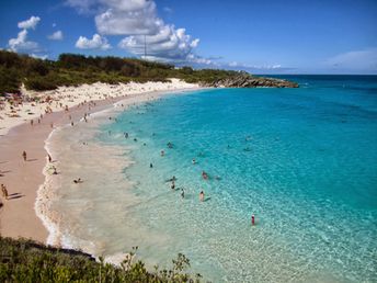
Horseshoe Bay beach

Ultimate guide (November 2024)
Horseshoe Bay - the best beach in Bermuda. Some said that beach sand color is pink, but it's not true. Shore and seabed: sand. [edit]
This beach ranks #4 of the "Best beaches in North America"
Rating: 8.4 - 708 votes [vote]
Coordinates: 32.252367, -64.821887
See also: Bermuda islands

Hotels [edit]

There are few hotels near the beach, but there's no much sense to settle there. You may choose any hotel on the island, and ride to the beach by car or by bus.

How to get there [edit]

Fly to Bermuda International Airport (BDA). Continue by taxi or by bus. In most cases it is worth to purchase Transportaion Pass (one or multi days).

When to go [edit]

Summer half of the year. The water is warmest in July-September. Winter weather is quite comfortable, but the sea water is too cold.

Rainfall, mm
Rainfall, mm

Water temperature, C

Temperature, C
Temperature, C

Humidity, %
Humidity, %

Wind speed, meter/sec

Open map

See also other beaches nearby:

 
Bermuda, Warwick Long Bay beach 7.9
1.2 km to the north-east
Location: North America, Bermuda
Rating: 7.9 (355 votes)
Bermuda, Elbow beach 8.2
4.7 km to the north-east
Location: North America, Bermuda
Rating: 8.2 (356 votes)
USA, Long Island, Coopers beach, parasols 7.0
1170 km to the north-west
Location: North America, USA, Long Island
Rating: 7.0 (209 votes)
British Virgin Islands (BVI), Jost Van Dyke island, White Bay, palm beach 8.8
1540 km to the south
Location: Caribbean, BVI, Jost Van Dyke
Rating: 8.8 (364 votes)
British Virgin Islands (BVI), Jost Van Dyke island, White Bay, Ivan's Campground, tent 8.5
1540 km to the south
Location: Caribbean, BVI, Jost Van Dyke
Rating: 8.5 (461 votes)
💖
If you liked this page, please share it on: Facebook, Twitter, Instagram
…or any other web-site
 
This will help the project greatly!

 
To the top of this page »
 
© 2024, Beach-on-Map.com · Menu