Beach-on-Map.com The Free Beach Guide HomeCountriesMenu

Jumbie Bay beach

Ultimate guide (September 2024)
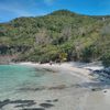
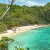
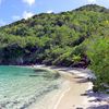
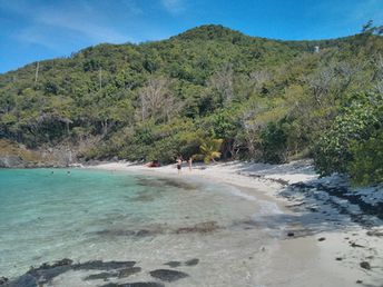
Jumbie Bay - mediocre beach near the Trunk Bay beach. There's no sense to move here. Shore: sand. Seabed: sand, stones. [edit]
This beach ranks #6 of the "Best beaches in St. John island"
Rating: 5.5 - 286 votes [vote]
Coordinates: 18.351514, -64.773589
See also: St. John island

Hotels [edit]

The nearest hotels are located near the Cruze Bay port.

How to get there [edit]

Fly to St. Thomas Airport. Get by shuttle bus to port of Red Hook. Next get by boat to Cruz Bay ferry pier (St. John island). Next take the shuttle bus going to the North shore road, and say that you need Jumbie Bay. There is a forest trail from the road to the beach (a few minutes walk).

When to go [edit]

Any time of year.

Rainfall, mm
Rainfall, mm

Water temperature, C

Temperature, C
Temperature, C

Humidity, %
Humidity, %

Wind speed, meter/sec

Open map

See also other beaches nearby:

 
American Virgin Islands (USVI), St. John island, Denis Bay beach, eastern part 7.2
280 m to the north-west
Location: Caribbean, USVI, St. John
Rating: 7.2 (112 votes)
American Virgin Islands (USVI), St. John island, Trunk Bay beach, view from the top 8.6
650 m to the east
Location: Caribbean, USVI, St. John
Rating: 8.6 (296 votes)
American Virgin Islands (USVI), St. John island, Oppenheimer beach, palm tree 8.7
660 m to the south-west
Location: Caribbean, USVI, St. John
Rating: 8.7 (741 votes)
USVI, St. John, Cinnamon Bay beach, azure water 8.4
1.9 km to the east
Location: Caribbean, USVI, St. John
Rating: 8.4 (111 votes)
American Virgin Islands (USVI), St. John, Maho Bay beach, palms 8.3
3.1 km to the east
Location: Caribbean, USVI, St. John
Rating: 8.3 (55 votes)
💖
If you liked this page, please share it on: Facebook, Twitter, Instagram
…or any other web-site
 
This will help the project greatly!

 
To the top of this page »
 
© 2024, Beach-on-Map.com · Menu